
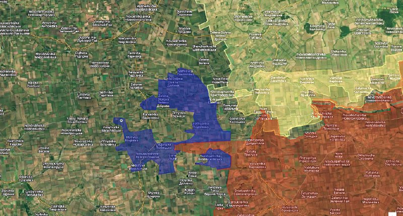
Northwestern Huliaipole Sector — Zaporizhzhia Oblast Map Legend: - 🔴 Red — Russian-controlled territory - 🔵 Blue — Russian-claimed advances (Since late September) - 🟡 Yellow — Ukrainian-controlled territory 1. Russian claims Since late September 2026, Russian military sources, including the Ministry of Defence and the Vostok Grouping of Forces, have increasingly reported territorial gains and advances northwest of Huliaipole. The claims have involved Samailivka, Svitla Dolyna, Zelena Dibrova, Barvinivka, Myrivka, Novosoloshyne, Lubytske and Vozdvyzhivka. Russian reporting has included alleged captures, advances towards settlements and claims of establishing positions in the surrounding areas. 2. Independent assessments Independent assessments have raised questions about the extent of these reported advances. The Institute for the Study of War (ISW) has documented discrepancies between Russian territorial announcements and geolocated battlefield evidence. Its September 25 assessment questioned Russian claims around Svitla Dolyna and Zelena Dibrova, noting that the claimed advances extended approximately 14–17 kilometres beyond the nearest assessed Russian positions. Subsequent assessments have continued to distinguish Russian claims of territorial gains from independently established ground control. Reports of infiltration and isolated Russian presence do not necessarily demonstrate sustained occupation of the settlements. 3. Mapping conclusion Taking into account the repeated Russian claims, reported advances and discrepancies identified by independent sources, we are placing the disputed settlements within the grey zone on our map. Blue markings represent Russian-claimed advances, not confirmed territorial control. The grey-zone designation reflects uncertainty over effective control and the possibility of Russian infiltration or limited ground presence. We will retain these classifications until sufficient geolocated evidence and independent battlefield assessments establish a clearer picture of territorial control. MAP : https://www.google.com/maps/d/edit?mid=1Qk0kokuoon-SInZeDakHY1NrwN-CY_w&usp=drive_linkhttps://www.google.com/maps/d/edit?mid=1Qk0kokuoon-SInZeDakHY1NrwN-CY_w&usp=sharing [We have modified Suriak MAP]